Day 60: Paraparamu Beach to Paekakariki

12km Day : 1077km Total
18 March 2015

It had been some time since I had taken a beach walk so today I started in Paraparaumu Beach to take the coastal track down to Paekakariki.

image

Paraparaumu Beach CBD

To some extent this walk reminded me of some of the walks I’ve taken in the Sydney area.  Including a short section through Queen Elizabeth Park that is similar to walking through Sydney’s Royal National Park.

image

Paraparamu Beach

image

Raumati Beach

image

Queen Elizabeth Park

I really enjoy the walks and stops in the small towns and cities.  They give me a better feel for the local atmosphere than i would get by only walking the “scenic” trails.  It has also given me several opportunities to briefly get to know several local Kiwis.

image

Paikakariki Sports Field

At the North edge of Paekakariki the sports field has natural bleachers made out of terraced landscaping.  So much better than the ugly steel trussed bleachers you normally see.

Posted in Uncategorized | Leave a comment

Day 59: Waitewaewae to Parawai Hut (Otaki Forks) and to Otaki the Next Morning

10km Day : 1065km Total
16 March 2015
-40.873374, 175.232077

Rain was not forecast until this afternoon but at three o’clock this morning I was awakened by a downpour on the roof of the hut.  It made me worry about a wet day ahead, but fortunately it didn’t last long.  When I woke up again at 6am Dave was already up and around.  He had left his motorcycle at Otaki Forks and was making a long day of it by this morning’s hike followed by a ride all the way to Auckland on his bike in the expected rain.  He left at the first hint of twilight.  I was in no hurry because I was planning another short day, and had a second cup of coffee before I took to the trail.

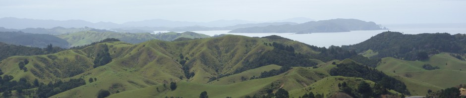
This section of trail stared out as very easy and pleasant walking but after a few kilometers it switched to a detour around what the trail notes call a big slip.  This was difficult trail to walk that sidled on a steep incline for several kilometers.  After what seemed like ages it came back to the main track , which was wide and smooth with occasional rail tracks and ties sticking out if it as it follows an old logging tramway that was abandoned years ago.  This then reached an open area just before Otaki Forks.

image

image

I reached Parawai Hut early, and since I only had a granola bar for lunch I pulled out the prized packet at the bottom of my food sack of a double serving Backcountry Meal (Beef and Pasta Hotpot) for an early gourmet dinner.

The rain held off until 6pm and just when I started thinking that I would have the hut to myself a young couple arrived.  They had driven up from Wellington specifically to stay at this hut.  It was clear that this was suppose to be a romantic getaway for them complete with full picnic gear and bottle of wine.  I certainly felt like a 5th wheel on this cart. Parawai hut has a covered porch so they spent their quality picnic time out there while I read a book curled up in my sleeping bag inside.

The next morning I got away early on my way out to Otaki via the road.  I expected this to be a 12km road walk considering that the road is isolated with little traffic and considering my history of bad luck hitchhiking.   After 45 minutes I reached Shields Flat where there are dry stone walls throughout a sheep pasture.  These were built during the Great Depression as a project to put men back to work.  They are very unique and something you might expect to see in Hobbiton.

image

A half hour later a car stopped to offer me a ride without me even sticking out a thumb.  This was only the 4th car I had seen all morning.  The generous driver (Charlene) that gave me a ride, pointed out a stand of tall trees that were used as a backdrop for a scene in one of the Lord of the Rings movies.

Just a note to other TA trampers, the trail notes discourage walking this road, labeling it narrow and winding.  But it is less dangerous than most of the road walks on the official TA trail. There is very little traffic, and on the winding section the cars are traveling slowly. 

Posted in Uncategorized | Leave a comment

Day 58: Nichols to Waitewaewae Hut

8km Day : 1055km Total
Ides of March 2015
-40.830917, 175.306189

The fog that enveloped the ridge yesterday afternoon had cleared by this morning and I had some fine weather to hike in.  As expected I woke up with sore legs and took some ibuprofen with my breakfast. 

image

Nichols Hut

The ridges this morning were smooth with easy trails to walk and amazing views to appreciate.  I took a very slow pace because I only planned a short hike down to the valley floor.  Far enough to get off the tops for tomorrow’s expected rain, but short enough to give my legs a rest.  The slow pace also gave me plenty of time to soak in the views.

image

On Mt Crawford I had mobile phone coverage which I used to inform friends and family of my revised expected completion of this section of hike.  I also changed some accommodation arrangements while I had the opportunity. 

image

image

image

Once below the treeline it became a steep descent down to the river.  This descent was not as difficult as I had expected considering how steep it was.  But there were still several places had to be careful not to lose my footing.

image

I arrived at Waitewaewae (YTYY) Hut early.  The log book showed that a group of eleven people stayed here last night, but I was still a little surprised when a hiker from Auckland named Dave showed up this afternoon.  He was the first person I had seen in two and a half days.  Dave is hiking a circuit around the Southern end of the range. Starting and ending at Otaki Forks.

Posted in Uncategorized | Leave a comment

Day 57: Te Matawai to Nichols Hut

12km Day : 1047km Total
14 March 2015
-40.810186, 175.375965

The weather was perfect for most of today with clear skies and cool temperatures.  The track followed the ridge line all day and because of the curve of the ridge I was able to look back at Te Matawai Hut for most of the morning.  It gave me a feeling that I wasn’t making progress every time I looked back and saw my starting point.

image

Looking Back at Te Matawai Hut

My thought this morning was that today would be easier than yesterday since I had already climbed to the ridge.  On the map the ridge appeared almost smooth with a few climbs and descents, but the trail was continually alternating sharply up and sharply down on a micro scale.  Meaning that there were a lot of ~20m dips that often required climbing with hands and feet to get down and up.  There were also a few spots with shear drops next to narrow trails.  A very challenging and exhausting hike.

image

image

The terrain alternated between short bush and moss covered forest.

image

image

There were some amazing views today, but it was quite a workout to hike through the day.  I took an easy pace but still felt winded at times and took many breaks.  I used these rest breaks to enjoy the views for extended periods.

image

image

image

image

In the late afternoon I climbed into a cloud layer and it started getting breezy.  I had also reached a point of exhaustion where even if the views weren’t obscured by foggy clouds I wouldn’t have appreciated them properly because all of my thoughts became focused on reaching Nichols Hut.

Posted in Uncategorized | Leave a comment

Day 56: Poads Road to Te Matawai Hut

14km Day : 1035km Total
13 March 2015
-40.73753, 175.398656

With only a few weeks left in New Zealand I’ve been giving consideration to which trails to hike during the time I have left.
While I was hiking on the South Island I had several other trampers tell me that the best trails on the North Island are in the Tararua Range.  So here I am.

I started at the trailhead at the end of Poads Road near Levin at 8 o’clock this morning.  Briefly walking through a pasture before climbing a forest path into the mountains.

image

image

Most of the morning I walked through a light fog so that even when in an open section of track it looked as if I was on an island in a sea of white.  It was a day mostly of climbing, starting with a thousand meter climb to Waiopehu then a 350m descent to Butcher Saddle before climbing another 250m.

image

The fog started to lift in the afternoon and gave me some views of the surrounding mountains.

image

image

image

I arrived at Te Matawai Hut at 5pm with sore legs from all of the climbing.  The last 2 weeks of being a tourist and doing little hiking has reduced my hiking fitness and made this walk a lot more difficult.

Posted in Uncategorized | Leave a comment

Day 55: Arrowtown to Queenstown

28km Day : 1021km Total
5 March 2015

For the past 2 weeks I have been a tourist.  With stopovers in Greymouth, Christchurch and now Queenstown.  Today I took a dayhike on a section of the Te Araroa trail to get myself back into a hiking frame of mind.

The day started at 7:30am when I caught a bus from Queenstown to Arrowtown.  Arrowtown is a historic gold mining town that is now full of novelty shops catering to tourists.  I stopped for breakfast and had a look around before starting my day’s hike.  I also picked up a half liter bottle of iced tea to take with me as I left my backpack and water bottles at the motel in Queenstown. I was looking forward to hiking with no weight on my back.

image

For most of the day the trail was well formed and well marked and had public toilets in strategic locations.  It was literally a walk in the park with great scenery to enjoy.

image

image

Lake Hayes

image

Spence Road Bridge

image

View from Upper Shotover Footbridge

Half way through the day I heard a familiar voice calling from behind.  It was Rory who I had last seen at St Arnaud after we had hiked the Richmond Track together.  We walked and talked together for the rest of the way to Queenstown catching up on each other’s adventures  from the last few weeks. 

We came to one section of the trail that was cut off by construction and fencing and required us to cross busy roadway several times risking life and limb.  I really think this was more dangerous than the Little Rintoul crossing we did last month.

In Frankton we stopped at a cafe overlooking the lake and was served by a friend of Rory’s that works there.  It was a wonderful view and I was very temped to say yes when asked whether I wanted another drink, but the trail awaited.

image

Frankton Arm of Lake Wakatipu

Queenstown is the ideal place for someone who enjoys outdoor activities.  Beside a lake in the mountains the opportunities are endless.  I talked to a dealer at the casino who says he only gets a few hours sleep per night in the winter because he skis the slopes all day and runs the roulette table at night.

It turns out that Joerg, who also hiked the Richmond track with me, is also in town.  We got together for a Fergburger and beer and spent dinner catching up.  Fergburger is a popular burger joint in Queenstown that almost always has people lined up out the door and up the block waiting to order.  I was not disappointed.  It was an excellent burger and worth a half hour wait.  Joerg and I were lucky with our timing and only had to wait about 15 minutes.  I had the Fergburger Double with cheddar.

Posted in Uncategorized | Leave a comment

Day 54: Locke Stream Hut to Morrison Footbridge and Otira

21km Day : 993km Total
18 February 2015
-42.788273, 171.603483

The hiking this morning was almost entirely on flat trail along the Taramakau River.  It included a lot of walking on stone beds some of which were large enough that I had to be careful not to turn an ankle, but not difficult walking for the most part.  It also included a couple of knee deep river crossings.

image

image

Orange Lichen-Covered Rocks

image

I reached Kiwi Hut around 10am, but the short side trail toward the hut required walking through a deep muddy water hole, which I didn’t feel necessary to cross just to put my name in the log book.  As I was leaving the hut area I saw a quad bike approaching from the west, which turned out to be a deer hunter.  He had shot a deer earlier and was returning with the bike to haul it away.  We had a few words about the weather and the sandflies and then went on our separate ways.

image

At the Otira River I started down the marked “Flood Trail” that lead to Morrison’s Footbridge.  But it soon became apparent how terrible this trail was with a lot of sidling up and down and crawling over and under fallen trees.  I soon decided to turn around and ended up crossing the Otira and walking the final 3km to the footbridge over the rocky plain along the river.

image

Otira River

I actually reached the road end of the footbridge without crossing the bridge since I did a wet boot crossing of the river an hour earlier.  I stopped here to change my socks and prepare for the 6km (not included in the above totals) road walk to the Otira Hotel. 

As I was sitting at the base of the bridge a passenger train passed by and I noticed that almost everyone on the train was staring out the windows and taking pictures.  I turned to see what they were looking at and realized it was simply the beauty of the mountain scenes all around me.  After walking in such scenery for so long I have become somewhat jaded to it.  This simple observation of the tourists on the train made me stop for the next 10 minutes and just take in the beauty.

image

Morrison Footbridge

The Otira Hotel is a unique icon.  With the decor of the place it could easily have been 1950.  With the walls covered with historical photos of the region and the restaurant, lounge and rooms filled with antiques, it is a rare treasure.  Sam checked me in and also acted as my cook (making me a whitebait burger), server and bartender.  And also arranged for a shuttle to take me in to Arthur’s Pass tomorrow morning.  The best service I ever had, all from this one marvelous person.

Posted in Uncategorized | Leave a comment

Day 53: Hurunui Hut to Locke Stream Hut

25km Day : 972km Total
17 February 2015
-42.739876, 171.830151

For the majority of the day I hiked along the Hurunui River toward Harper Pass.  The terrain around the trail varied throughout the day including forest, grasslands and rocky fields.

image

Hurunui River

image

Sheep on the Grassy Flats

image

I reached Hut #3 around a quarter past eleven and decided to eat an early lunch since the hut would give me relief from the swarms of sand flies that invariably find me whenever i stop moving. 

As I was preparing to leave the hut, Ollie arrived and mentioned that he was planning to make a long day of it and hike to Kiwi hut.  My goal for the day was to just get to the other side of Harpers Pass and to stay at Locke Stream Hut.  After a little more discussion of the trail ahead I was back hiking. Ollie caught up and passed me near Harpers Pass Bivvy where I stopped to refill my water bottle and rest.

image

Inside Hut #3

When I was approaching Harpers Pass I was not too concerned since it was less than a 200m climb to the pass.  What I hadn’t taken into consideration was the steep 500m descent on the other side.  It was slow going down to Locke Stream Hut on a steep, rocky, rooty trail with many stream crossings.

image

View to West of Harper Pass

image

Lots of Stream Crossings

I reached the hut just before 6:30 with no energy left.  It is a large hut with many bunks and tonight I have the hut to myself, except for a large resident rat that is mentioned several times in the log book.

image

View from Locke Stream Hut

Posted in Uncategorized | Leave a comment

Day 52: Hope Shelter to Hurunui Hut

25km Day : 947km Total
16 February 2015
-42.703745, 172.096141

I got up early and packed up my tent and was off by 7:15 this morning.  I reached Hope Shelter at 7:30 to find 2 trampers from Israel making their breakfast.  After a brief discussion with them and signing the hut book I was back on the trail.

image

The morning walk was a good mixture of forest trails along the Hope River followed grassy plains on the way to Lake Sumner. 

I reached Hope Kiwi Hut before 10am and stopped for a brief rest and a snack inside away from the sandflies.  I saw from the hut log book that no one stayed there last night.  Which somewhat explained the mess on the countertops.  It appeared as if the mice having no backpacks to rummage through resorted to chewing up the candles.  There were bits of wax and mouse droppings all around the candle holders.  I did my best to clean up the mess before moving on.

image

image

image

A Unique Bridge

image

Beech Forest Trail

At noon I followed a side trail to a lookout point above Lake Sumner where I stopped to have lunch.  Unfortunately the trees blocked most of the view of the lake.  While I was there I was joined by a NOBO TA hiker from San Diego named Andrew.  We gave each other descriptions and recommendations for the trails ahead since we were traveling in opposite directions.

image

Lake Sumner from the Lookout

image

Lake Sumner from Western End

image

Natural Bridge

I reached Hurunui Hut a little after 4pm and decided to make an early day of it.  I took my time setting up my bunk and making dinner of ramen noodles with dehydrated peas and real bacon bits.  After I finished eating, Ollie from Germany arrived at the hut followed soon afterward by the 2 Israeli hikers, whose names escape me at the moment.  After some discussion about gear (the Israelis are ultralight at about 6kg base weight) we all made an early night of it.

Posted in Uncategorized | Leave a comment

Day 51: Windy Point to Camp East of Hope Shelter

7km Day : 922km Total
15 February 2015
-42.612545, 172.307468

I started this morning in Hanmer Springs after rest and resupply.  I had the intention of hitchhiking back to Windy Point to continue the hike where I left it.  My thought was that I would start hiking again by noon.  But leaving Hanmer the traffic was light.  So I started the 8km walk back to the highway intersection making a conscious effort to turn and put out my thumb for every car.  But no one stopped and I ended up walking all of Hanmer Springs Road again.  I did get a good view of the Waiau Ferry Bridge and crossed it for the second time.

image

Waiau Ferry Bridge

Just on the other side of the bridge is a small cafe where I stopped for another grilled ham and cheese.  The main road to Windy Point was just on the other side of the cafe.  Walking the main road was not an option since Windy Point was 35km away. 

I stood at the intersection for a frustrating hour with my thumb out and got no ride.  I finally gave up and called the shuttle bus company who said they had a shuttle going through the area that could pick me up at 3:40 and take me to Windy Point.  I’ve never liked hitchhiking, and today’s experience amplified that sentiment.

image

It was after 5pm before I got back to hiking at the point I left the trail.  So I only got a couple of hours of tramping in before I stopped and put up my tent for the night about one kilometer East of Hope Shelter.  Once I got my tent set up and everything inside I went through the typical 10 minute ritual of ensuring that every sand fly inside the tent was dead.  Tonight I killed around 20 of them.  There are swarms of them around the tent and a lot of them got in even though I made an effort to keep the netting closed as much as possible.

image

image

Posted in Uncategorized | Leave a comment